Hiking the shifting sands in three of the Park Service’s iconic
dune fields
Great Sand Dunes National Park & Preserve
Sand dunes conjure up memories of family camping trips to
the Oregon Coast where my sisters and I would roll down steep dunes only to
giggle our way back to the top and do it again.
Over and over, as only kids can do.
At that age I thought sand dunes were exclusively an ocean thing. But as I grew older, I learned that sand
dunes are also found far from the ocean.
I’ve recently explored some great inland sand at Kobuk Valley National
Park in Alaska, White Sands National Monument in New
Mexico and Great
Sand Dunes National Park & Preserve in Colorado.
Living in Alaska for the past 38 years gave me a unique opportunity
to visit some exceptionally cool and out-of-the-way wilderness in our 49th
state. When I started with the National
Parks Conservation Association in 2002, I quickly embraced the need to visit
all 16 of Alaska’s
national park units. That
included Kobuk Valley National Park, located about 35 miles north of the Arctic
Circle and only accessible by small plane or river boat. Kobuk Valley has been a park since the Alaska
National Interest Lands Conservation Act was signed by President Carter in
1980.
There are actually 3 dune fields in the park, remnants of a
much larger 200,000 acre dune field that was created during the Little Ice Age,
which began about 28,000 years ago. The
area around Kobuk Valley was not glaciated so the winds gathered sand scoured
by the surrounding glaciers and created the dunes. When the ice retreated about 14,000 years
ago, the boreal forest began reclaiming the sand leaving us with the three remnant
dune fields we have today. The largest
is the Great Kobuk Sand Dunes, 16,000 acres of the best and most accessible sand
in the most northerly active dune field in the world.
Visiting Kobuk Valley and the Great Kobuk Sand Dunes begins
with an Alaska Airlines flight to Kotzebue where we chartered a small plane
(see the park’s commercial
operators for air taxi options) for our three day dune camping
adventure. Some air taxi operators land
on wheels in the dunes and others land on floats on the Kobuk River. I had been there once before with the Park
Service and knew about the sand landing option which saved us from a two mile hike
from the river through the mosquito-infested boreal forest to the dunes. It is much easier to land near where you want
to camp.
There were four of us, including several NPCA staffers from
Washington DC. My supervisor was pretty
nervous about camping in bear country. Just because we were camped on sand
doesn’t mean there are no bears, so I secured a small electric
fence to put up around her tent so she could sleep anxiety free. We
saw both wolf and bear tracks in the dunes and I made certain my traveling
companions understood how to behave in bear country. Each had their own can of bear spray. You need good backcountry experience to do
this trip safely.
Hiking on sand dunes, surrounded by boreal forest above the
Arctic Circle was surreal. Before I got there,
I could not imagine sand dunes in the interior arctic. We spent two days exploring on day–long walks,
marveling at the wave patterns in the sand created by the ever present wind, hiking
to the top of the higher dunes and rolling down like we were kids, and photographing
wildflowers growing in sand. The Western
Arctic Caribou Herd migrates through this area and we wished our trip had
coincided with the right time of year to experience caribou on sand. And we pondered just how long before the
forest totally reclaims these dunes. It
won’t happen for a while, so you have plenty of time to get out here and enjoy
this totally unique park.
Great Sand Dunes National Park & Preserve in Colorado is
a much bigger and more accessible dune field.
These are, in fact, the highest dunes in North America and have been
protected since local residents successfully lobbied for a 1932 national
monument proclamation. The area was
expanded to its current boundaries and renamed a park and preserve in
2000. The sand captured in these dunes
originated about 65 miles west in the San Juan Mountains. As the sand blew east it mixed with sand and
pebbles washed down from the Sangre de Cristo Mountains and it was all stirred
together in an ancient lake. As that
lake receded, the prevailing winds from the west pushed the sand up against the
Sangre de Cristo Mountains and created dunes that today are over 750 feet high.
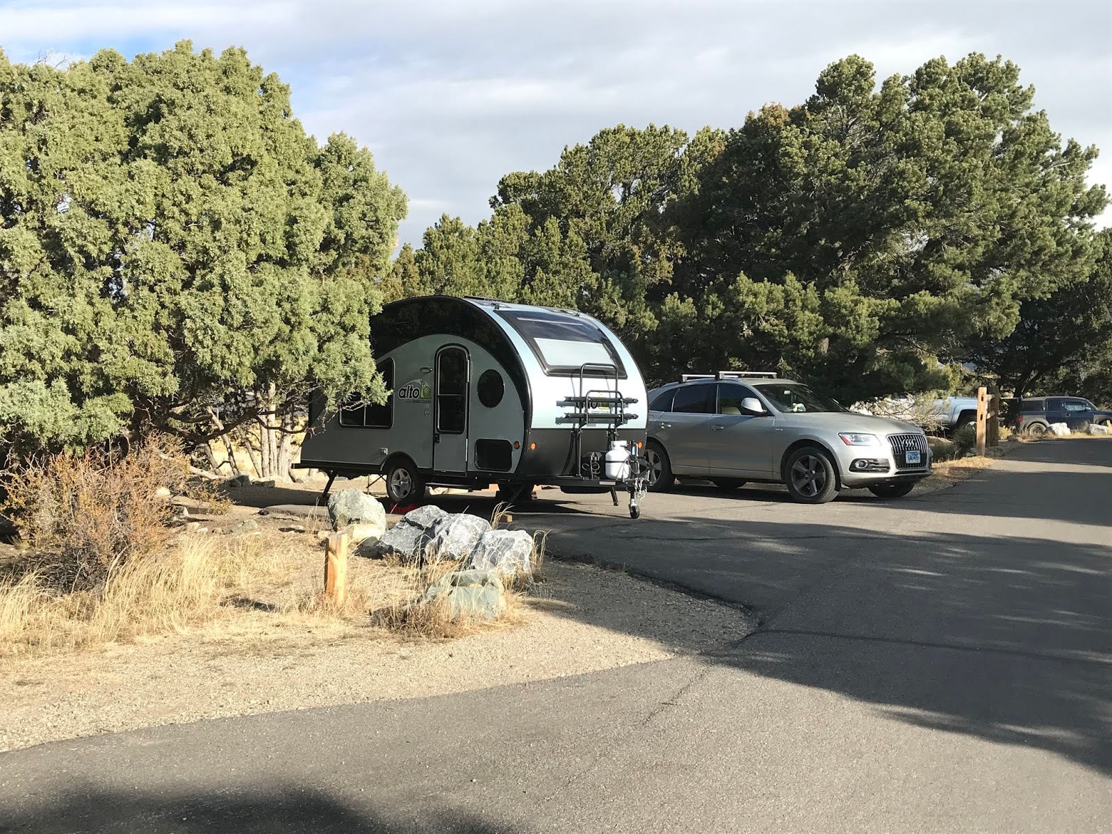
Camping at Pinon Flats Campground in our Alto trailer
My girlfriend Craig and I rolled into the Pinon Flats
campground mid-afternoon and easily found a place to park our little Alto
trailer for a three day stay. The campground is open April through October
and reservations are accepted from May to September. In addition to information on how to safely
explore the dunes, the visitor center oriented us to hiking options in the
juniper-pinon woodlands at the dune’s edge, as well as trails to higher
elevations into a subalpine and alpine tundra environment in the Sangre de
Cristo Mountains. We didn’t get into the
high country, preferring to explore the sand.
The campground is a stone’s throw to the dune field, so we hiked
from our campsite. Medano Creek is your
first obstacle. We were there in
October, so it was very shallow and easily crossed without getting our boots
wet. A unique feature of this creek are
these mesmerizing wave-like pulses of water caused by water building behind small
ridges of sand in the creek bed and as these ridges give way, a small surge of
water flows downstream. We timed our crossing
to avoid these pulses, dancing across the stream and on to the dunes.

Medano Creek and Sangre de Cristo Mountains
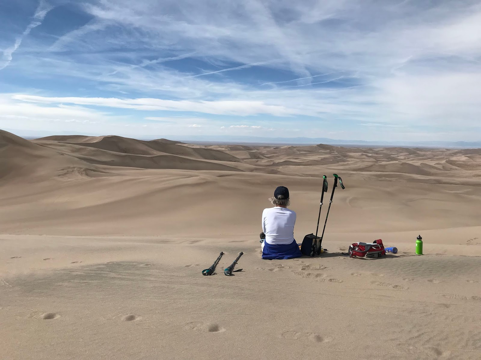
The dunes are a series of windblown ridges and we set our
sights on a mid-dune ridge about halfway up.
The thought of climbing up 750 feet in shifting sands to the top of Star
Dune (one of the park’s highest) made my calves spasm in anticipation. But once we started out, the sand was firmer
than we expected. We were not climbing
where many others had gone and later we found that once the sand was loosened
by lots of hikers on the more popular routes, it was a bit of a grind. But on this less-traveled sand we easily
walked up ridges that beckoned us to see what was beyond the next highest
one. Soon we were on top, standing on Star
Dune and gazing across thousands of acres of shifting sands. And, as in Kobuk Valley, we discovered life
on the dunes. We followed tracks of
beetles, had ladybugs land on our hats, watched ravens surf the wind and
wondered where butterflies thought they would score some nectar high in the
sand. And coming down was way easier and
a lot faster than climbing up!

Coming down off the dunes!
The next day the wind was really blowing and hiking on the
sand was a non-starter. Good thing we
did our dune walk when the wind was but a mere whisper. So we explored the juniper-pinon forest on
the Wellington Ditch Trail, just above the sand edge – a very reasonable one-mile
trail from the campground to the visitor center. As an added bonus, after years of looking, I saw
my first pinon jays!! A whole flock went
squawking by and I imagine my “I-just-saw-the-bird” dance was a little amusing
for those on the visitor center deck. Glad
I was able to entertain them!

One more ridge beckons us!
This is very much a "local" campground with lots
of campers from Pueblo and Colorado Springs.
On one of our campground walks, we ran into a group of Boy Scouts and
their leader told us about a nearby hot springs. Our aching muscles rejoiced! Don’t let the name get in the way – Sand Dunes Swimming
Pool and RV Park. It is about
an hour away in Hooper, CO and, in addition to the swimming pool that was full
of kids, there is the Greenhouse, an adults-only section with four different soaking
pools of varying temperatures and a bar!!
We took advantage of a nice hot soak to ease the muscles that were
talking to us after our day of hiking in sand.
And on the way over, we stopped off at San Luis State Wildlife
Area to watch the Sandhill cranes come in for the evening. A fine way to end the day.
White Sands National Monument in New Mexico doesn’t have the
elevation of Great Sand Dunes – most of the dunes we hiked on were well under
100 feet high – but it is no less of a cool place. Nestled into the Tularosa Basin just east of
Las Cruces, New Mexico, this 275 square miles of white gypsum sand is the
largest of its kind in the world.
Alamogordo is actually the closest town to White Sands, but we were
traveling down I-25 from Santa Fe, so stayed in Las Cruces.
In the most recent ice-age, the one that also helped form the
Great Kobuk Sand Dunes, gypsum was eroded from the surrounding mountains and
collected into what is now known as Lake Ortero. As that ice age retreated some 12,000 years
ago, the gypsum deposits on the lake bottom had grown to as much as 3 feet
thick and were exposed to the wind. As
the exposed gypsum crystals were broken down into smaller particles, they
became the white sands that we see today.

White Sands National Monument - dunes and the vegetated bed of ancient Lake Ortero
The dunes here are very close to the water table, which does
two things. First it allows for
vegetation to grow. Deep roots on
plants like the skunkbush sumac will hold sand in place and create pedestals
when the surrounding dunes move on.
These little vegetation islands provide denning habitat for kit
foxes. The second advantage of a high
water table is keeping the sand moist and firmer than regular dunes. This makes for great hiking.
For over 100 years, nearby residents knew they were living
next to someplace special. The first
attempt to protect these sands was in 1898 when residents of nearby El Paso,
Texas proposed Mescalero National Park.
That didn’t fly and neither did a proposal in 1922. But in 1933 President Herbert Hoover listened
to a group of Alamogordo citizens and used The
Antiquities Act to create White Sands National Monument.
In addition to the recreational opportunities that abound
here, White Sands is also known for its military history. The monument is surrounded by the White Sands
Missile Range (think atom bomb testing) and Holloman Air Force Base,
and the monument is occasionally closed for missile testing. There are signs at trailheads warning hikers
not to approach any ordinance they might find stuck in the sand.

Watch out for bombs on the trail!
We started off at the Works Progress Administration built
visitor center to get oriented on what to do and where to go. This is a very classic adobe style building at
the center of a national
historic district protecting all the WPA era buildings at park
headquarters. This is a fee park and the
eight mile road leading to the Heart of the Sands picnic area begins at the
entrance station. There are several
great trails to explore along this road and there are lots of signs about what
you cannot do in the dunes, including having alcohol from February 1 to May
31. This was a bit confusing until we
learned that this was a big spring break party spot…until NPS banned alcohol.
Within the first couple miles is the Dune Life Nature Trail,
the Playa Trail and the Inter-dune boardwalk. We did all three and each was a bit
different. The Dune Life Trail is along
the edge where the desert scrub meets the gypsum sands. It is a one mile loop that got us into lots
of vegetation and vegetation pedestals.
There are 14 interpretive trail signs hosted by Katie the Kit Fox, the
trail’s mascot, marking the way. This is
a well-designed and interpreted trail. The
Playa Trail is a one-half mile out and back trail that took us to the edge of a
small dry lakebed that seasonally has a bit of water. Skip this one if you are short on time. The accessible Boardwalk Trail is a .4 mile
out and back trail that is a self-guided experience interpreting the wildlife
and vegetation in the heart of the dunes.

Solitude at White Sands National Monument
But by far the best way to experience the white sands is to
take several hours and hike the 5 mile loop of the Alkali Flat Trail. This trail gets you into the heart of the sand
where you hike up dunes, walk along ridges and down across exposed areas of the
vegetated hardened gypsum lake bed.
There are wands in the sand to keep you on track, so it is virtually
impossible to get lost. But in case you
do, there is cell coverage. This was one
of our best hikes of the year and one I’d do again in a heartbeat. We left most people in the first quarter-mile
and had the dunes to ourselves. There are
no interpretive panels, just the opportunity to explore the sand, listen to the
silence, share the space with horned larks, watch the weather against the
surrounding mountains and experience the solitude of being in the middle of
thousands of acres of moving white sands.
We thoroughly enjoyed all three of these very different sand
experiences and look forward to exploring more of the park system’s sand dunes. Anyone up for Indiana Dunes?


